World famous for Robin Hood and the Sheriff, Nottingham owes much of its prosperity to the lace industry, Raleigh's bicycles and its coal fields further north. The River Trent forms part of the Grand Cross devised by the great canal engineer James Brindley, to build canals to connect England's four main rivers – the River Thames, Severn, Mersey and Trent. This leafy walk takes you along the Green Flag Award-winning green corridor created by the Victoria Embankment alongside the River Trent and the Nottingham & Beeston Canal through the heart of Nottingham.
Circular canal walk in Nottingham
Enjoy a leafy waterside walk through the heart of Nottingham, passing along the Victoria Embankment, the River Trent and the Nottingham & Beeston Canal.

Canal: Nottingham & Beeston Canal and River Trent
Start and finish: Wilford Street Bridge OS Grid ref: SK571393 Postcode: NG2 1AA
Distance: 5.6km / 3½ miles
Route instructions
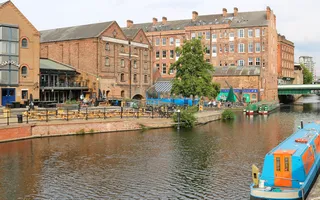
Start: The ornate cast-iron Wilford Street Bridge overlooks Castle Lock and the Navigation Inn to one side and to the other side the Grade II-listed British Waterways Building which dominates the canal here. Built in 1919, it would once have warehoused goods carried along the canal but is now set to be converted into apartments. Walk east along the towpath.
1. On the opposite side of the canal by the blue footbridge, Castle Wharf is vibrant with cafés and bars in warehouses once busy with boats loading and unloading. The former Fellows, Morton & Clayton warehouse is now a pub with the additional quirk of narrowboats in a canal extension inside. The Wharf is overlooked by Nottingham Castle, high above the city, built in 1068 by William The Conqueror, and of course synonymous with a certain Robin Hood.
2. Walk up and over what was a short canal branch, then head up the ramp next to Carrington Street Bridge. Turn right to follow the pavement along Carrington Street over the railway and past the grand façade of Nottingham railway station.

3. Turn right into the part-pedestrianised Queensbridge Road and walk straight on, taking care when crossing roads, until you reach Queen's Walk. The Walk runs in a straight line down to Wilford Bridge on the River Trent, with the tramline running through it. Bordered on both sides by trees, ‘story poles' are dotted along the route, carved into remains of some of the lime trees originally planted here, including one sculpted into the young Queen Victoria who visited Nottingham in 1843.
4. When you reach the open landscape of the river, turn left to follow the gloriously leafy Victoria Embankment along the water's edge. Opened in 1901 and constructed with ten miles of concrete steps, it is now one of Nottingham's largest green spaces. This part of the river is unnavigable so look out for swans, Canada geese, ducks and moorhens taking advantage of the grassy banks as well as the quiet water. Benches invite you to linger a while.
5. Just beyond the white Grade II-listed Wilford Suspension Bridge, a new visitor centre is being constructed at the Memorial Arch by the Memorial Gardens.
6. The distinctive blue ironwork of the famous arched Trent Bridge, opened in 1871 and now Grade II-listed, straddles the water. Notice river level marks on the wall by the bridge, October 1875 being one of the highest. The bridge leads to the world-renowned Trent Bridge Cricket Ground, and you can also see the lights of Nottingham Forest's football ground across the river.

7. Meadow Lane Lock marks the start (or end) of the Nottingham & Beeston Canal which was built to bypass an unnavigable section of the River Trent. A short distance further along on the south bank of the river is the entrance to the currently unnavigable Grantham Canal. Cross the footbridge to follow the towpath away from the river.
8. The canal runs in a straight line through a cutting bordered by the A60 heading into the city, though noise intrusion is limited. Behind the wall on the right of the towpath is Nottingham County Football Club ground.
9. At Poplar Arms Corner, once a junction, walk up the steps to cross the bridge, and then back down to follow the canal towpath on the opposite side of the canal as it turns sharply westwards.
10. The towpath heads under two adjacent bridges, the higher of which carries the tramway over the canal.
End: Once you have walked under Carrington Street Bridge, you have come full circle back to Castle Wharf.

Last Edited: 27 February 2025


Stay connected
Sign up to our newsletter and discover how we protect canals and help nature thrive


