We'd love to tell you more
Our newsletter is packed full of exciting updates and stories of how our charity keeps canals alive.
The charity making life better by water
Making life better by water
The Llangollen Canal crosses the border between England and Wales. Its combination of picturesque countryside and breath-taking engineering draws visitors from far and wide.
Length | 46 miles |
Locks | 21 |
Length | 21.95m 72ft |
Width | 2.08m 6ft 10" |
Draught | 0.70m 2ft 3" |
Headroom | 2.13m 7ft |
Our newsletter is packed full of exciting updates and stories of how our charity keeps canals alive.
Show me places within...
Explore your nearest canals and ways to enjoy them Find walks, activities and more within:
The Llangollen Canal crosses the border between England and Wales. Its combination of picturesque countryside and breath-taking engineering draws visitors from far and wide - many of whom probably don't realise how close this beautiful canal once came to closure.
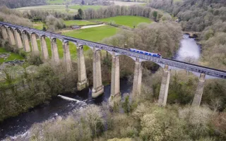
The majestic Pontcysyllte Aqueduct, the tallest navigable aqueduct in Britain, which carries the canal over the River Dee, is a masterpiece of engineering and an icon of the Industrial Revolution. In 2009 along with 11 miles of canal and its associated structures, the aqueduct was awarded World Heritage Site status.
The aqueduct stands 126 feet high and has 19 arches that span 1007 feet in total. Whether crossing on foot or by boat the drop is dramatic The aqueduct is fed from the nearby Horseshoe Falls and holds an incredible 1.5 million litres of water.
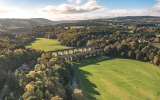
The Llangollen Canal and its surrounding area has attracted visitors for 200 years. Why not walk from the town to Horseshoe Falls at Llantisillio or visit Chirk with its pairing of aqueduct and viaduct and short but surprisingly dark tunnel.
We've put together free guides detailing all you need to know to have a grand family day out along the Pontcysyllte Aqueduct World Heritage Site and Llangollen Canal.
The Llangollen Canal is a great place to start for beginners. Why not paddle the right way (our Welsh version) - our guide to canoeing the Pontcysyllte Aqueduct and Canal World Heritage Site.
We're improving the towpath along the Llangollen Canal
We've begun work to improve the towpath along the Llangollen Canal in Shropshire close to the nearby Pontcysyllte Aqueduct and Canal World Heritage Site which, once finished, mean visitors can enjoy easy access to the waterways and a safe green, traffic free route from Shropshire to the Horseshoe Falls at Llantysilio, Denbighshire.
The project will see the 1400 metres of towpath improved and widened from Gledrid, which links Shropshire to the World Heritage Site, to the Lions Quay Hotel and Spa. The £180,000 programme is being funded by the European Agricultural Fund for Rural Development. Once completed it is hoped more people will visit the canal and World Heritage Site giving a welcome boost to tourism in the local community.
The Llangollen canal was designed by two outstanding figures in the history of civil engineering, William Jessop and Thomas Telford, who used new techniques to cut through rugged terrain and cross two valleys.
Their great aqueducts, tunnels, bridges, cuttings and embankments, most of which can still be seen today, marked a significant stage in the evolution of transport. This was an outstanding engineering feat for its time and the Pontcysyllte Aqueduct alone took more than ten years to complete, with the final stone being laid in 1805 at a total cost of £38,499 (£38 million today).
The Llangollen Canal we see today is quite unlike what the original promoter's intended. The Ellesmere Canal Act of 1793 was to link the River Mersey to the River Severn at Shrewsbury, past Chirk, Ruabon and Wrexham to the Dee at Chester, then continuing to the Mersey at what was to become Ellesmere Port.
Branches to the limestone quarries of Llanymynech and the town of Whitchurch were also proposed. Its purposes were to be a trunk route joining the three rivers, to provide an outlet of the coal and iron industries of Denbighshire, and to enable limestone to be distributed to fertilise the farmlands of north Shropshire.
The part north of Chester was built first. Next, some of the intended canals south of where the Dee was to be crossed by Pontcysyllte Aqueduct were constructed, including the branch to Llanymynech and much of the branch towards Whitchurch — the canal company then ran out of money. The plans had to be altered.
The Ruabon to Chester section was abandoned, as was the canal into Shrewsbury; instead, the Whitchurch branch was extended to meet the Chester Canal at Hurleston Junction. A new source of water was needed, so a navigable feeder was built from the north end of Pontcysyllte Aqueduct, past Llangollen to the Dee at Horseshoe Falls.
The canal was mainly used to transport limestone from Llanymynech and Pontcysyllte to limekilns along the canal and to its Prees branch and later following the opening of the Birmingham & Liverpool Junction Canal to the ironworks of East Shropshire.
This group of canals became part of the Shropshire Union in 1845, and soon afterwards was leased to the London & North Western Railway. Traffic peaked in the 1860s, then slowly declined, ceasing in the 1930s.
The Llangollen Canal was closed by Act of Parliament in 1944, following a second act it was able to stay open for a further ten years to supply water to various industries. An enterprising manager negotiated with the water company serving south Cheshire for them to obtain their water from the Dee, using the canal as an open pipeline. By the time this came into effect in 1959, the canal was becoming popular with holidaymakers, and the future of the canal was assured.
Sign up to our monthly newsletter and be the first to hear about campaigns, upcoming events and fundraising inspiration