Castleford is an important junction between the Rivers Aire and Calder, and owes its very existence to the River Aire. Roman legions used it as a crossing point and in 1704 the river was made partly navigable by the Aire & Calder Navigation Company. During the Industrial Revolution, potteries and flour mills were built, and a thriving trade route developed between Leeds and Wakefield. Still a busy commercial route today, you may spot barges transporting cargoes such as gravel but don't forget to look out for the wildlife living here too.
Historic canal walk at Castleford
Walk through 900 years of history on a 2.5km stroll along the Aire & Calder Navigation at Castleford.

Canal: Aire & Calder Navigation
Start: Queen's Mill OS Grid ref: SE429259 Postcode: WF10 1JL
Finish: Bulholme Lock OS Grid ref: SE434267 Postcode: WF10 2LL
Distance: 2.4km / 1½ miles
Route instructions
Start: With over 900 years of history, the stunning Queen's Mill was acquired in 1921 by the Allinson family, who turned it into the world's largest stone-grinding flour mill, using a traditional method with 20 pairs of stones to grind wholemeal flour. Up to the 1970s, the mill was powered by the River Aire via a large waterwheel.
1. A sculptural map pinpoints some historic events and locations around Castleford, including the birthplace of the sculptor Henry Moore in 1898, Castleford Pottery, the Rivers Aire and Calder, the bridges and of course the mill.
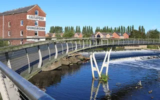
2. Walk over the River Aire via Millennium Bridge as it flies in an ‘S' shape to the other side of the river. The bridge gives a dramatic bird's-eye-view of the crashing water of Castleford Weir below and the remains of a wrecked barge which has been there since 1977. Officially opened in 2008, it is the first major bridge in the UK to be fully Forest Stewardship Council (FSC)-certified, with curved timber boards from sustainable forests in Brazil. A ‘fish pass' helps fish species to climb the weir to the river above, including migrating eels and Atlantic salmon, while otters use the steps.

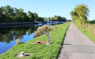
3. Turn left at the end of the footbridge to follow a path along the leafy embankment to the right of the river, passing allotments and Lock Lane Bird Garden. The embankment is part of flood defences for the town, and is now a great place to spot wildlife and birds so keep your eyes peeled for heron, kingfishers and even otters.
4. You reach the dramatic water crossroads setting of Castleford Junction. Follow the towpath past boat moorings to the road bridge. A path leads to the pavement where you turn left to cross the canal, then turn left again down a slope back to the towpath.
5. Continue straight ahead to Castleford Junction Lock and former toll office - the route is shared with vehicles so be aware. Castleford Junction Lock is normally left open unless there are flood conditions. There are glorious expansive views at the junction where the Aire & Calder Navigation heads north to Leeds, the Wakefield Branch heads west to Wakefield, and east leads to Bulholme Lock and beyond to Knottingley and Goole. You could take a mile-long detour alongside the water to the former mining village of Allerton Bywater and its waterside pub.

6. Back at the road bridge, follow the towpath underneath and continue past a boatyard and moorings opposite. Be aware the wide towpath is again shared with vehicles. A hedgerow bursting with berries and chattering birds hides another embankment and fields of chomping horses on your left, while the water on your right is edged with moored boats.
7. A gate leads to the Fairburn Ings RSPB Reserve in a landscape shaped by mining and converted to wetlands, grasslands and woods alongside the River Aire. Look out for breeding birds such as curlews and visiting birds like the gadwall.
8. Bulholme Lock sits in a wooded setting and leads to the River Aire below. Over 8ft deep and 200 feet long, it is controlled by traffic lights or the lock keeper using the observation tower alongside. Over two million tons of freight, such as gravel, oil and sand, is transported along the Aire & Calder Navigation each year. You may be lucky enough to see one of the huge barges, weighing up to 700 tonnes, using the lock.

End: Take time to relax in your surroundings before retracing your steps back to the road bridge. You then have a choice – either follow the pavement along the main road back to the Mill, or retrace your steps along the river embankment.

Last Edited: 27 February 2025


Stay connected
Sign up to our newsletter and discover how we protect canals and help nature thrive


