Accessibility for visitor moorings at Brecon, Gloucester, Bath, Bathampton, Bradford on Avon, Devizes, Hungerford, Newbury, Saul Junction
Brecon 48 hour mooring - Monmouthshire & Brecon Canal Rings or Bollards: Bollards
Towpath surface: Paved
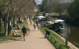
Accessibility to hinterland: The Brecon 48 hour towpath mooring has accessibility for all, including wheelchair access to the mooring.
Car Parking: There is no Trust owned car park at this site, there is however a pay to stay car park close by.
Toilets: There are toilets and facilities for boaters just past the 1st bridge after 48 hour mooring.
Google maps
Horseshoe Walk, Bath - Kennet & Avon Rings or Bollards: Posts
Towpath surface: Grass & gravel
Accessibility to hinterland: Slopes at either end
Car Parking: Limited 2 hour road bays
Toilets: None near, but some in town centre
Google maps
Bathampton School - Kennet & Avon Towpath surface: Grass & gravel
Accessibility to hinterland: The moorings are step free so easily accessible for all although the small section at the end of the Visitor moorings where the water point is located is down 2 shallow steps. There are numerous benches situated under the large oak trees to rest and enjoy all the comings and goings.
Car Parking: Short term parking running parallel to the canal with slightly longer parking available a short drive away in the village of Bathampton.
Toilets: The only toilet facilities in the area are at The George Public house, a stones throw from these moorings.
Google maps
Bradford -on-Avon below - Kennet & Avon Rings or Bollards: Rings
Towpath surface: Gravel, grass
Accessibility to hinterland: Slopes. A shopping centre is on the same side as the moorings approx 200 yards away. The Lock Inn Cafe is nearby.
Car Parking: Trust car park, 150 m above lock 14
Toilets: Above lock 14
Google maps
Devizes Wharf - Kennet & Avon Rings or Bollards: Rings
Towpath surface: Grass & gravel
Accessibility to hinterland: Slopes at either end
Car Parking: Council car park on offside opposite the moorings
Toilets: Toilet facilities are available in the Wharf tea rooms close by
Google maps
Hungerford Wharf - Kennet & Avon Rings or Bollards: Rings
Towpath surface: Grass
Accessibility to hinterland: Level step free access. Partial gravel slipway to waters edge, most of the moorings are grass side.
Car Parking: No Trust or other car park on site, 2 hour parking bays available in residential road alongside. Tesco carpark approx 400 yards away.
Toilets: No toilet on site but one can be found at Tescos or in town centre
Google maps
Newbury Wharf - Kennet & Avon Rings or Bollards: Rings
Towpath surface: Grass & gravel
Accessibility to hinterland: Slopes. A shopping centre is on the same side as the moorings approx 200 yards away.
Car Parking: Wharf carpark on opposite side to the moorings. Pay and display carpark on mooring side.
Toilets: None near, but some in shopping centre
Google maps
Gloucester Docks 48 hour mooring - Gloucester & Sharpness Canal Rings or Bollards: Rings or pontoons
Towpath surface: Paved, tarmacked
Accessibility to hinterland: Access to Gloucester Quays shopping centre, many pubs and restaurants, Gloucester Waterways Museum.
Car Parking: Gloucester Quays
Toilets: There are toilets that are situated by the Alexandra warehouse, opposite the Edward Elgar holiday cruiser. Also in the shopping centre.
Access to the 48 hour pontoons.
Access to the 48 hour pontoon at the north quay end.
This is the west quay wall leading up to the Gloucester lock. This has mooring rings and an electric point. It is quite a high wall.
Google maps
Saul Junction - Gloucester & Sharpness Canal Rings or Bollards: Bollards
Towpath surface : Grass & tarmac
Accessibility to hinterland: level
Car Parking : The car park is in reasonable condition and is split into 3 parts. Each part has its own pay machine accepting cash, credit or phone pay
Section 1, on the right just after the Stables café is in good order.
Section 2, on the right side after the Cotswold Canal Trust Visitor centre, is smaller but well used and popular.
Section 3, at the far end of the site is the largest and has 10 designated disabled bays with easy access to the towpath
Toilets: In the Stables Café and a disabled toilet in the Cotswold Canal Trust Visitor Centre
Google maps
Last Edited: 18 October 2021


